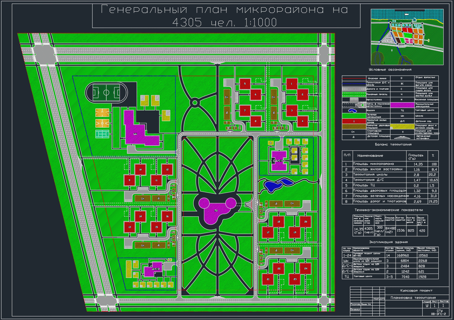
General Plan of a Residential District

- Added: 17.03.2021
- Size: 2 MB
- Downloads: 4
Description
General plan of residential area by calculation
Project's Content
|
|
|
|
|
|
|
|
- AutoCAD or DWG TrueView
- Microsoft Word
Additional information
Contents
Contents
1. Preliminary calculations
2. Description of the organization of yards
3. Transport and pedestrian links in the microdistrict
4. Justification of project proposals
5. Technical and economic indicators of the project
6. Territory balance
List of literature used
Section 4: Justification of project proposals
The territory of the microdistrict is limited by red lines of streets and roads: from the north, from the east and from the south - main streets of citywide significance with regulated traffic, which provide transport communication of the microdistrict with other areas and a public center, from the west - a main street of district significance. Also, a residential street is designed inside the microdistrict, which serves the microdistrict as a whole. On the eastern main street of urban significance, a stopping point for public passenger transport has been designed.
Groups of residential buildings are located in the north-western, eastern and southern parts of the microdistrict along the red lines of residential streets and near kindergartens. The territory of the microdistrict provides for the placement of preschool institutions (two kindergartens), a general education school, as well as institutions and service enterprises.
It is proposed to place a comprehensive school for 825 students in the west of the microdistrict. Two kindergartens, each with a capacity of 220 seats, are supposed to be placed in the west and southeast of the microdistrict, respectively. In this case, the pedestrian accessibility condition is observed (Table 5 * [1]) not more than 750 m and not more than 500 m for primary classes to all residential buildings of the designed microdistrict. The service radius of kindergartens does not exceed the requirements of the norms (Table 5 * [1]) and is not more than 300 m.
In the microdistrict, a cultural center is designed, located in the east, which provides for the placement of trade, catering and consumer services. The center is connected with a group of residential buildings by a boulevard. There is also an underground parking lot for the temporary storage of vehicles of service personnel and the permanent storage of cars of the population of the microdistrict.
To organize recreation and leisure of people, a boulevard with fountains is designed, located in the center of the microdistrict and connecting a school, a cultural center and kindergartens.
The landscaping system, the main element of which is the microdistrict garden, is provided for continuous. The tracing of the road network was carried out in accordance with the directions of the main paths of people and taking into account the shortest distances to objects of various purposes (institutions, residential buildings) and improvement elements (gaming, sports and other venues).
Section 5: Project Feasibility
The area of the microdistrict in the red lines is 13.35 ha.
The population of the microdistrict is 4305 people.
The population density is 300 people/ha.
The number of apartments is 1532, including one-room - 766, two-room - 606, three-room - 160.
The total area of apartments is 78740 m2.
Section 6: Territory Balance
The area of the microdistrict is 13.35 hectares, including:
the area of kindergartens - 1.78 hectares;
the area of the school is 2.14 hectares.
The area of the microdistrict, excluding school and kindergarten territories, is 9.55 hectares (100%), including:
area under development - 1.65 hectares - 17.28%;
coverage area - 2.95 ha - 30.89%;
landscaping area - 4.95 ha - 51.83%.
![]() планировка.dwg
планировка.dwg

Similar materials
- 01.07.2014
- 01.07.2014
- 09.07.2014
- 09.07.2014
- 09.07.2014
- 09.07.2014


